The diminished status of local and state history in New York extends to the first human settlers here as well. First contact between the European colonists and the Indian Nation inhabitants famously begins with Henry Hudson sailing the river the river that flows both ways that now bears his name. Over the course of the next two centuries, from the Hudson to the Erie Canal, the Indian Nations played an important role in the history of the colony and the state. By the time James Fenimore Cooper wrote The Last of the Mohicans: A Narrative of 1757 first published in 1826, that world had vanished: the Canal was completed, New Yorkers had forgotten about the Oneida Nation’s participation in the American Revolution as our allies, and William Johnson had been dead for decades. As one might sing/ask at the end of a musical, “Who will tell their/our story?”
Nearly two centuries later, the Indian Nations are still here. They exist in a vastly different environment and are probably best known for their casinos. They still are viewed as two-dimensional beings although since values have changed sometimes that makes them superior beings as one with nature instead of savages antithetical to civilized beings. Perhaps one day they will become three dimensional and not the victim of stereotypes.
At the annual conference of the Association of Public Historians on New York State (APHNYS) last September in Liverpool, I chose to participate in the field excursion to the nearby Skanonh Lodge Great Law Peace Center. It is part of the Onondaga Nation, the tribe that was at the geographical center of the Haudenosaunee people. Similar centers exist along the Mohawk Valley for other members of the confederation.
During the tour, I asked our tour leader, who is a reader of my posts, about the collaborative efforts with the other facilities. Unfortunately, his reply was negative. Each facility does its own thing.
During past Teacherhostels/Historyhostels, we have visited various sites in the eastern half of the Mohawk Valley related to the Haudenosaunee:
Fenimore Art/Farmers’ Museum
Indian Castle Church
Iroquois Museum
Johnson Hall State Historic Site
Old Fort Johnson
Old Stone Fort
Shrine of Our Lady of Martyrs.
The extension to the western half never materialized. I did scout out the Oriskany Battlefield and Fort Stanwix but never put the pieces together for a program.
Last January, I was an invited guest of the Oneida Nation to participate in workshop at Turning Stone Resort. The purpose of the meeting was to help prepare a grant application to the NEH to produce a documentary on the very Battle of Oriskany. By further coincidence. I previously had been contacted by the Oneida County Historical Society in partnership with the National Park Service which manages the sites of Oriskany and Fort Stanwix (in Rome) about being involved in planning for the 240th anniversary in 2017. I suggested that they along with the New York State site in Little Falls for General Nicholas Herkimer be invited to the Oneida program which they were. Herkimer had bled to death from injuries sustained in the battle. The American general was part of the Palatine settlement in the Mohawk Valley. These Germans too are a forgotten part of American history. By coincidence, the Oneida are popular performers in Germany but the connection with the Palatines in the Mohawk Valley has not been developed.
In a recent newsletter from HISTORIC LEWISTON NEWS, there was an announcement about an upcoming lecture by Neil Patterson, Sr., Tuscarora Council, on “Little Known Facts in Tuscarora History.” The description of the talk is:
Much of the local Tuscarora history has been written by white people, with little or no input from the Tuscaroras. As in any culture, Native American oral traditions run deep and are sometimes reluctantly shared.
The speaker is from the Sand Turtle Clan and a member of the governing Tuscarora Council. He worked as a consultant during the construction of the new Tuscarora Nation House. He has been the coordinator of the Tuscarora Nation Picnic & Field Days for over 30 years. In 2009, he began a four-year collaboration with the Historical Association of Lewiston and the Village and Town of Lewiston to complete the Tuscarora Heroes Monument in time to commemorate the 200th Anniversary of the heroic actions by Nation in saving the lives of local Lewiston settlers.
So here we have an example of another new facility on behalf of one of the Haudenosaunee nations.
I have not been to Ganondagan, the Seneca site near Rochester.
I am not familiar with the Seneca-Iroquois National Museum in Salamanca.
The places mentioned here are not meant to be exhaustive. They suggest the geographic range of possibilities in constructing a Haudenosaunee Path through History in the event anyone should want to do so. The list does not include museums in New York City and Albany which also tell the story.
I would be remiss in this post if I did not mention the North Country. Besides the Fort William Henry, we had the opportunity in a Teacherhostel/Historyhostel to hear Rick Salazar, an Abenaki storyteller, talk with us on Mount Defiance near Fort Ticonderoga. As he was talking a storm moved across Lake Champlain. It was possible to see the comparatively sharp lines between the storm and the sunlight as it traversed the lake. There were moments when we could see sunlight on either side of the storm. It was truly a wondrous sight as it quickly passed. The scene provided a perfect venue to hear about the Abenaki culture. Naturally, I claimed to have arranged for this special effect as part of the program and for no additional charge. I don’t think anyone believed me.
Finally, the Iroquois and the Women’s Right movement were part of the discussion in the plenary address of Sally Roesch Wagner at the second Women’s Suffrage Centennial Conference. In response to my recent post on that conference, Doug George-Kanentiio, a member of the Mohawk Nation, author of Iroquois Culture and Commentary, and vice president of the Hiawatha Institute for Indigenous Knowledge, sent me an article from the Washington Post on that subject. Doug periodically sends me emails in response to my blogs. One was an educator’s guide to the Sullivan-Clinton campaign prepared by Robert Spiegelman. I confess that I don’t know what the status is in the new k-12 social studies guidelines for teaching that campaign. But just as 2017 marks the 240th anniversary of the Battle of Oriskany so 2019 will mark the 240th anniversary of the Sullivan-Clinton campaign. These are opportunities to create culturally enriching programs that bring people to the actual locations of where people in history lived and events occurred and to hear about them in mentally-challenging ways which stimulate thinking.
I regret not having visited the Hiawatha Institute for Indigenous Knowledge in Syracuse when I attended the APHNYS conference in nearby Liverpool. According to its website:
The Hiawatha Institute for Indigenous Knowledge (HIIK) was established on February 19, 2011. The Institute is the fulfillment of a dream first envisioned by the Oneida leader Shenandoah 200 years ago: his wish was to provide a place of learning where the essence of Native knowledge would be shared with the world in a school of higher learning.
A group of contemporary scholars, educators and community leaders have renewed the vision. The group consisted of delegates from the member nations of the Haudenosaunee (Six Nations Iroquois) Confederacy…They were there to do what they could to preserve the culture and traditions of the Haudenosaunee as distinct Native peoples while making available specific instances of our ancestral knowledge to anyone who has a desire to live in harmony with the earth by protecting the rights of those yet to be born onto the seventh generation. Named after one of the creators of the Haudenosaunee Confederacy over 800 years ago, the HIIK will work in partnership with Syracuse University to offer degrees…from a distinct Native perspective in an inclusive curriculum designed by aboriginal knowledge keepers and unique among all institutions of higher learning in North America.
As you can see from this post so far, there are a lot of opportunities and a lot of pieces to be put together to create Haudenosaunee Paths through History. Back then Palatines, Dutch, French, and English weren’t just white people, they were different tribes and nations in their own right; the same applies to the various Indian Nations that are lumped together today. The story of William Johnson attempting to keep the peace among a vast multitude of differentiated peoples is part of the story of New York and American history. The story of James Fenimore Cooper writing when New York had become the Empire State and Johnson’s world was barely a memory also is part of the story of New York and American history. While no venue exists to bring the players together, while there is no leadership from the state, and while there is no funding, one still can envision the possibilities of creating Haudenosaunee Paths through History despite the obstacles to doing so.
I definitely am so pleased you published this !
I have for several years been interested in our local history involving our Village and its coincidentally Indian Name of Coxsackie . We have never been able to realize the true meaning of the name .
Do you have information :
Hi Margaret,
I found this on the Coxsackie website written by Michael H. Rausch – Town of Coxsackie Historian http://coxsackie.org/sample-page/history/
The name Coxsackie is said to be derived from a Native American term, and over 350 years has had various spellings: Koxhacking, Koixhacking, and Koxsackie are three of the over 60 different recorded spellings. There are also multiple translations with references to: owls, geese, and aspects of the nearby river. “Hoot of the Owl”, “Place of Owls”, and “Migrating Geese” are a few of these translations. Even the best scholars have not agreed to the exact meaning, but locally, the widely accepted meaning has to do with owls, and the owl has often been used a local symbol.
Thank you for promoting Native American History. I have been learning so much about the original people here in the Hudson Valley Region since I moved into the area in 1986. The mighty Hudson River has always been an inspiration and I have explored much off it in a kayak. I am a figurative sculptor and back about 16 years ago I learned about a great man who was not in the history books. His name was Daniel Nimham 1726-1778. He was likely the last official sachem of his people (Wappinger) prior to their move from the eastern side of the Hudson River up to Stockbridge, MA. From what I have learned, Nimham after serving in the French Indian War with his fellows for the English, became outspoken after lands rightly owned by the Wappingers had been stolen by land grabbers who extended their properties when the men went off to war and the women were safely staying in Stockbridge. Nimham spoke English and went to court to try and win these lands back. He and a number of other chiefs even went to England to plead their case before the King in 1776. Upon returning the court threw out the case. About this time Nimham and his fellow Stockbridge militia decided to fight for the American cause in hopes that their loyal service would be awarded with a place for their people. The Stockbridge Militia fought in battles in NJ to Boston. In August of 1778 while on maneuvers in what is now Van Cortland Park. At around 11 am the fifty or so of militia were surrounded by 500 Hessian, British regulars and calvary under Col. Simcoe. The battle lasted until 7pm in the evening and most of the militia had been killed including Daniel and his son Capt. Abraham Nimham. I have created a sculpture of Nimham and hope to see this work eventually in a life size bronze statue. More information may be found on my website.
Thank you for promoting Native American Studies. Here is a project I am working on about an almost unknown hero of the Wappinger/ Mahican People.
http://www.keropiansculpture.com/daniel_nimham.html
Your post is most informative and interesting! I might suggest that it might be enhanced by offering actions that can be taken to achieve the proposed trail . One would be a tour that would link the possible sites, possibly broken into two segments.
Since all of us push local areas, I am not remiss in pushing the Oswego River Valley. While not on the East-West path, it was still an important trail to Lake Ontario and Canada, as well as the West.
Pressure from the affected areas might get the state to move.
Charlie Young,
Scriba Town Historian
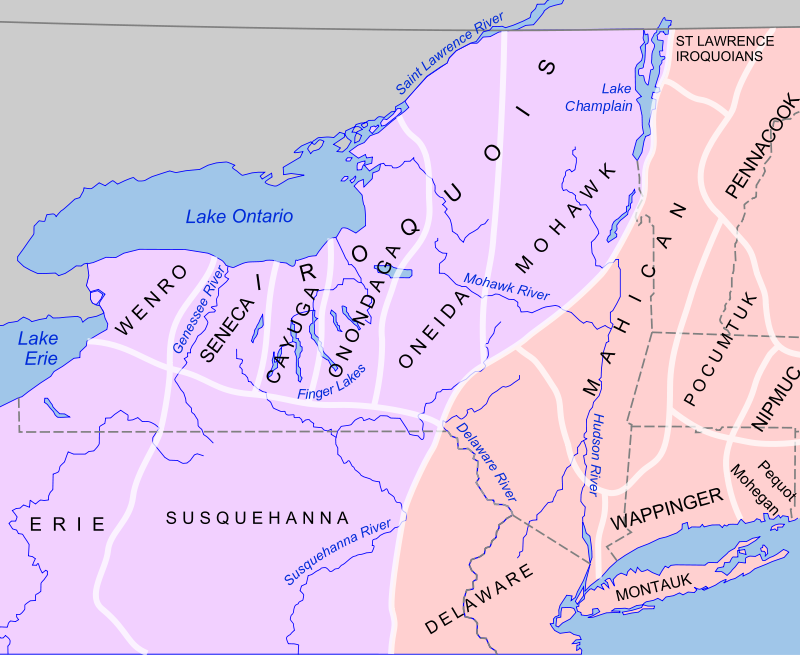
“Wenro” ? I never saw that name before. The Seneca’s were alway called “the guardian of the Western gate”, while the Mohawks were “guardians of the eastern gate”. Need to look up Wenro. West of the Senecas, for sure.
As for General Herkimer: a technical pont here: he didn’t die of his injuries, but from a botched amputation because of those injuries. A novice, inexperienced surgeon worked on him; he bled out and died as a result.
The “Palantines” – several interesting stories:
Up on the Livingston manor, on BOTH sides of the Hudson, the British gave them free passage from Germany if they agreed to work the “Tar Camps” set up for them there. The British needed that turpentine and tar for their navy. Dirty, ugly work and it turned out that the pine trees were not the right species to do it efficiently. “Not like the pines of the Carolinas”, it is written. They pulled out and left for the Schoharie Valley where they ressttled – tho this day. I have pix of “East Camp Road” up near Clermont, and now understand where that name came from.
It also, now, finally explains why the U of North Carolina team nickname is “The Tarheels” ! I never could understand that. NC is also the Tarheel State, no ??
When my hero John Stark’s parents came over to start life here from Ulster province in N. Ireland, settling up in NH, they also found that they were NOT the right kind of pine trees to make it a going industry either. Had to start a sawmill, instead.
The nation west of the Genesee has usually been known as the “Neutrals,” a name which is weird. The Erie were also called the “Cats.” In the Beaver War era, the Senecas exterminated the Erie and through the 17th and 18th century expanded to the Niagara, slowly absorbing remaining bands of people and truly extending to New York’s Western edge.
Hi Mike. this is a late post. I am trying to find out if an Indian trail went along the east side of Honeoye Lake and saw your post. The local history section of the Rundel Memorial Library in Rochester, York has a Libra website which may add to your knowledge about the Neuters, as the French called them. They possessed almost all the land west of the Genesee River. The Seneca were at that time east of the Genesee and extended to about Canandaguia Lake. The story of the Neuters is that they forbade any kind of warfare within their territory, and I personally have read a report, on the site listed above, where a group of Iroquois stayed in a lodge of the Neuters along with some Delaware whom were their mortal enemy [but did not fight]. The report however says that the two different tribal members glared at each other the entire night! The Neuters were wiped out by the Seneca, as too the Erie. In the first case the Neuters were wiped out because of their possessing land the Seneca wanted. The Erie were wiped out because of the shale on the south shore of Lake Erie which was perfect for arrow heads. Hope this assists in some way. While the actual name of the Neuter Nation is locked away in one of my notebooks, may I note that it was the French whom gave them this name to which you refer
Peter –
Terrific, Peter…
The truest as well as saddest statement is the one where we recognize Native American “history and prehistory,” in all the Americas, has largely been written by non-Indian people with a Western, and often biased, perspective.
I like your map of NYS and how it allow much more territory for Mohican homeland (Mohicans prefer Mohican rather than Mahican, an artifact of Colonial interpretations). Most maps give the Haudenosaunee half of the Hudson Valley!
P.S. Teaching the history as well as the prehistory (my area) of Native America become very difficult when unbiased primary resources are so limited. Archaeologists are often forced to “guess,” as it is, and biased literature makes it all the more difficult.
Tom
Tom Lake
Estuary Naturalist, Hudson River Estuary Program
in partnership with New England Interstate Water Pollution Control Commission
New York State Department of Environmental Conservation
21 South Putt Corners Road New Paltz NY 12561—1696
Great info!
BTW, do you have any info on the Mohansic Nation which was the former name of FDR State Park in Yorktown? It’s a shame they changed the name back in the early eighties to coincide with FDR’s 100th birthday, considering that there are so many other locations in the state named after him.
Just so you know, the lake there is still called Mohansic Lake!
Their tribes ceased to exist around 1640 or so, which is why I never heard of them:
Wenro Location
Western New York and northwestern Pennsylvania centering around the present town of Cuba, New York.
Population
The Wenro were a small tribe of somewhere between 1,200 and 2,000 people. The number of their villages is unknown, but from the pattern of their dispersal in 1639, there appears to have been either two or three. The Wenro ceased to exist as a tribe in 1643. Any descendents would be found among the Iroquois, the Seneca of Oklahoma, or possibly the Wyandot.
Names
Wenro is a short form of their Huron name, Wenrohronon, meaning “the people of the place of floating scum.” The name derived from the location of their main village near the site of the famous oil spring at Cuba, New York. Other names given them by the Iroquois, with approximately the same meaning, were Ahouenrochrhonon and Ouenrionon.
Language
Iroquian
Culture
What little is known about them has come to us from the Huron, since there was no direct contact between the Wenro and Europeans until after a large group of Wenro refugees came to the Huron villages in 1639. Oil was highly prized by the Iroquian tribes in the region for its medicinal properties, and the trade for this commodity is the major reason the Wenro maintained good relations with the Huron. It can safely be presumed that the Wenro lived in a manner very much like their other Iroquian neighbors. If true, they farmed extensively (corn, beans and squash) with hunting, gathering, and fishing providing the remainder of their diet. Political and social organization are unknown, but since all other Iroquian people traced descent through the
mother, it is probable the Wenro did also. None of their village sites have been specifically identified, so their housing (large longhouses) must have been the same as the Iroquois who lived in the area after the Wenro had been forced to abandon the area. It is not known whether their villages were fortified, but considering their situation, this should have been the case.
History
The Wenro occupied a strategic position at the eastern end of Lake Erie just south of Niagara Falls that possessed a valuable item in Native American trade, oil. This alone may have been the reason they were the first victim of the Beaver Wars. As a small tribe, they were required to protect themselves from the large confederations which surrounded them (specifically the Iroquois) through a three-way alliance with the Erie to the west and the Neutrals across the Niagara River in southern Ontario. However, their closest ties, language and cultural, appear to have been with the Neutrals. For reasons unknown, the Wenro alliance with the Erie and Neutrals ended during 1639. The withdrawal of their protection by the Neutrals apparently was critical. As an epidemic swept through the Wenro villages that year, the Iroquois learned that the Neutrals would no longer help and attacked the Wenro.
Quickly overrun, most of the Wenro were driven across the Niagara River into Ontario. Many moved in with the Neutrals, but one large group of about 600 Wenro were given refuge by the Huron Confederacy. However, one group of Wenro remained east of the Niagara River and fought with the Iroquois until 1643. Finally forced to abandon New York, the survivors fled west and became part of the Neutrals. At this point the Wenro had ceased to exist. Their reprieve was only temporary. The Wenro with the Huron were either killed or captured (and later adopted) in 1649 when the Iroquois destroyed the Huron Confederacy. Two years later, the same fate befell the Wenro that had become part of the Neutrals (1650-51), when the Iroquois vanquished this rival.
Your article is interesting but along the area near Little Falls — Snells Bush Church (St. Pauls Dutch Reformed Church) should be included. This little community that developed in the Town of Manheim is where the early Palatines settled.
In 1733 the Palatines settled this area of the Mohawk Valley and though the years there have been 3 churches built on this site. The site where the church stands is part of the original land grant which was given to the Snell-Zimmerman Family by King Hendrick chief sachem of the Mohawk Indians. This land grant was called the Snell-Zimmerman land grant of 1734 and 1755 as this land grant was given twice because the British government would not accept the original document of 1734. The grant was divided between Johan Jost Snell and Jacob Zimmerman and the sons of John Jost Snell gave seven acres for the church to be built and twelve acres for a school to be built. A very active farming community developed at Snells Bush. During the Revolution this church was one of churches that participated in the mustering of the militia for the march to the Battle of Oriskany
The grant of 3600 acres was a gift from the Mohawk Tribe to Anna Margaret Timmerman for her friendship to the Mohawks and we the Snell- Zimmerman-Timmerman family today hold the actual 1755 document of the land grant. We are very proud of our friendship with the Mohawks and the Indians are always welcome to our events,
I just finished reading today’s New York State Indian Paths through History and saw that you have not yet visited Ganondagan State Historic Site! As the Ganondagan public relations/marketing consultant, I’m sending you a personal invitation to visit, especially with the new Seneca Art & Culture Center that opened in October 2015.
Please consider a visit so you can see firsthand how Ganondagan is an internationally recognized resource for Haudenosaunee history, culture and living traditions that express universal ideals of peace, cooperation and respect for each other and the natural world.
I look forward to hearing from you soon.
Best wishes,
Amy
Glad Peter drew attention to this really important and really overlooked cultural and historical aspect of the region’s history! Amy is right, Ganondagan is a wonder in every aspect and should not be missed!! It also gives attention to the lesser known Native-French relations that shaped the history of New York. You might also want to visit the Rochester Museum & Science Center to see the fabulous art of Ernie Smith – or go online to the “Native Things” collection curated by Terry Abrams (Seneca Tonawanda): http://collections.rmsc.org/LibCat/Ogweoweka.html
The Johnson Papers are digitized and provide an excellent reference point for much of what Peter discusses as possible features of a “Path” project: https://archive.org/stream/paperssirwillia01unkngoog/paperssirwillia01unkngoog_djvu.txt
Loved the article and the graphic!
Hi, do you have information on Indian paths in the Downtown / Village area of Manhattan? Basically, anything below, say, 34th St.?
Peter:
I would refer Lincoln to the Welikia Project (formerly known as the Mannahatta Project), the brainchild of Eric Sanderson of the Wildlife Conservation Society. The project digitally recreates the flora, fauna, and landscape of the NYC region of 1609. Eric has done extensive research, gathering information from far-flung historical and scientific sources, to reach his conclusions. I suggest you visit welikia.org to learn more about Eric’s work.
The project’s companion book “Mannahatta” has a chapter (number four) on the native inhabitants of today’s Manhattan, their settlements, and trails. In fact, page 105 shows a map of the Lenape trails.
The data from the project has been loaded into a website of OasisNYC, so you can see the trails (and a LOT of other stuff) without buying the book. Here is how to see the trails:
1. Go to this webpage: http://www.oasisnyc.net/ .
2. Click the link labeled “1609 Mannahatta imagery” in the text of the second bullet-point paragraph.
3. A map will appear. To the right of the page is a list of menu headings with check boxes. Uncheck all the boxes that are already checked (under the menu headings “Transit, Roads, Reference Features” and “Parks, Playgrounds and Open Space”). The map should now be essentially blank except for a satellite-style image of pre-colonial Manhattan.
4. Open the menu heading “Historical Land Use.” Then check the box marked “1609 Lenape Trails.” The trails will appear on the map.
If you wish to contact Eric, here is his e-address: esanderson@wcs.org .
As you may know, the Smithsonian’s National Museum of the American Indian is located in downtown Manhattan. They may have more or better information on this topic, but I’m not sure. You may want to contact them if Eric’s data prove inadequate.
Good luck.
Best,
Michael Miscione
Manhattan Borough Historian
Finally got a chance to do something beside write reports. I took a look at some of your IHARE items. One item in “Who will tell our story” (excellent, by the way) I have a question about. I don’t doubt the citation, just curious as to where it is found and am hoping you can lead me to it. Found in the paragraph beginning “Nearly 200 years ago, Marquis…” “…when he visited the Oneida, he discovered that the New Yorkers living in the nearby communities had little to no memory, etc.” Any help with this would be gratefully appreciated.
Hoping all is well and flourishing and Thanks for all you do, Leigh
Leigh C Eckmair, Historian/Archivist
The Local HIstory Collection
The Gilbertsville Free Library
ph 607.783.2832 or 607.783.2820
“Who will tell the story” comes from the closing song of the musical Hamilton
For a description of LaFayette’s visit to Utica see Joseph T. Galatthaar and James Kirby Martin Forgotten Allies:The Oneida Indians and the American Revolution pages 4-5.
Always good to hear from you,
Peter
I enjoyed your posting. I am Richard Salazar. Native American Historian. I have a BA in Anthropology. This was before there was any Native American Studies programs. So I had to my design degree along the native lines. My family has been putting on a powwow for 45 years locally here in the So. Glens Falls area. I am also a native American re-enactor of the French & Indian war and American Revolution. You have seen the Fort Stanwix visitor center video about the fort and the battle of Oriskany. We did that for the fort years ago. We have done others as well. They being the visitor center movies at Fort Crown Point , Rogers Island and many other documentaries of that time period. I have also built exhibits in Fort William Henry in Lake George, Rogers Island in Fort Edward , and the West Point Military Museum. I am a speaker and presenter of local and Iroquois history. . If I may be of assistance, please contact me.
sincerely,
Richard Salazar
ph. # 518-793-5273.
Ganondagan is not to be missed. A beautiful peaceful place. The Seneca Iroquois National Museum in Salamanca is great and is always having programs open to the public with a very knowledgeable curator, David Shongo Jr. And speaking of North County, add another for your list, the Akwesasne Cultural Center in Hogansburg, NY. A beautiful place and many fine examples of basket making which is alive and well there. They teach classes. I found the curator, Sue Herne, to be extremely helpful when I was looking for photos for my book. Their website is http://akwesasneculturalcenter.org/
Dear Nichael Keroplan:
My name is Louis Alpert and i serve as the Obudsman for the Rockland County Times, Rockland’s Official Newspaper since 1888
My recent weekly column concerned the need to add back the word “Tappan Zee” to the iconic bridge connecting Westchester and Rockland County. Unfortunately, as you may be aware, those words were removed by the current NY Governor in favor of dedicating this bridge to his father , Mario Cuomo, and even rejecting a compromise which would re-title the bridge The Mario M Cuomo Tappan Zee Bridge.
The reason for my e-mail today us to ask you for a contact name of an historian sensitive to needs of the Hudson Valley Region to retain i.ts roots in the culture of both the Tappan Indians and early Dutch settlers.
As one of the spokespersons who would like to preserve these roots for our region, it would be of great interest to me to request such an historian to add his name and statement supporting this need so that the efforts of our coalition can be further supported,
Please respond to me at almath2000@gmail.com
Sincerely, Dr. Louis Alpert, Ombudsman for the Rockland County Times
I am sorry but I do not know who Nichael Keroplan is or why you submitted this comment here. In regards to your query, since you are in Rockland I would suggest starting with the historians in Rockland:
Mary Cardenas Orangetown historian who lives in Tappan and is the director of the Orangetown Museum otownmuseum@optonline.net
Craig Long the Rockland County historian history.detective@verizon.net
or the County of Rockland Historical Society.
.Hello
Do you know of a map showing Native American trails along the Susquehanna River? I live in Center Village and have found hundreds of artifacts along the bank. I believe I saw a map once that showed the Lackawanna Trail following what is now Rt79 but now I cannot find it . I read the Susquehanna River Expedition and have become fascinated with the archeology. I have found a number of effigy tools , an Eagle, A Bear , and a Turtle. I appreciate any additional insight that you can provide